Austin Thanksgiving weather forecast: Cold nights, chilly days
Austin weather: Chilly temperatures coming
We'll have a couple of warm days and then things will start to feel like winter. Leslie London has all the details in her full forecast.
AUSTIN, Texas - It will be a warm start to the week, but a series of cold fronts will bring back the chill. The first one arrives on Monday around lunch. It will produce more wind and rain and bring back jacket weather Monday night.
Wind gusts of 20 to 30 mph are possible, and we will go from the low 80s in the early afternoon to 40s by Tuesday morning.
Buckle up and get ready for a wild ride in the temperature department. We have a strong cold front coming to town for Thanksgiving with cold nights and chilly days lasting through the weekend.
Keep an eye on FOX 7 for where and when to expect the rain.
DOWNLOAD FOX LOCAL AND THE FOX 7 AUSTIN WEATHER APP
Thanksgiving travel rush at the Austin airport
It's going to be a busy week! FOX 7 Austin's Jessica Rivera has the details.
Traveling
A majority of Americans from coast to coast should arrive at their Thanksgiving destinations without too many issues. However, that forecast changes for the end of the week just as people prepare to head home after the festivities.
Nearly 80 million people are expected to travel 50 miles or more this Thanksgiving, with peak travel days falling on the Tuesday and Wednesday before the holiday and the Sunday afterward.
West Coast braces for more rain, mountain snow ahead of Thanksgiving
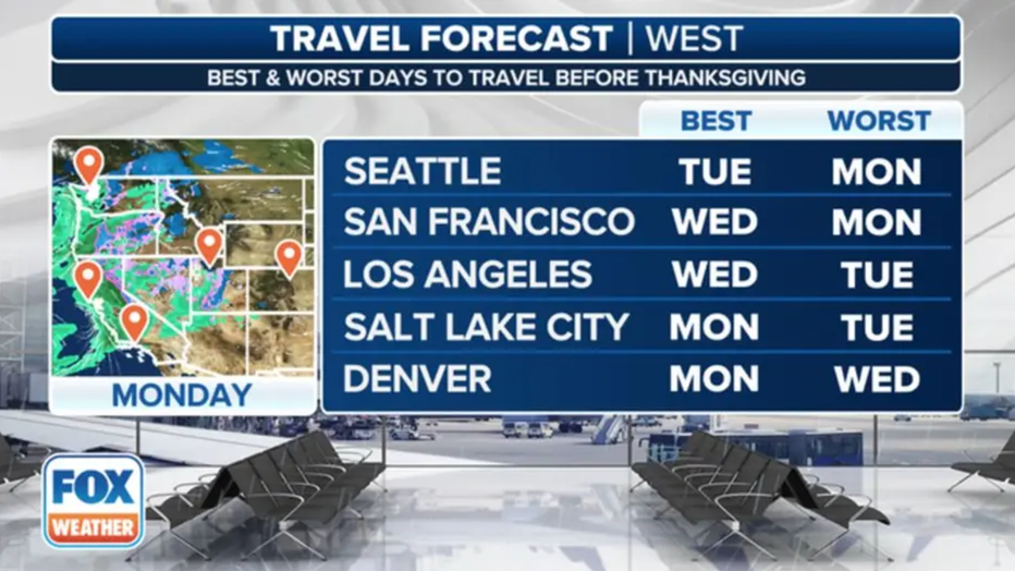
This graphic shows the best and worst days to travel for Thanksgiving in the West. (FOX Weather)
The deadly, multiday atmospheric river event that slammed portions of the West last week has come to an end. But the FOX Forecast Center is continuing to track the last of a series of low-pressure systems approaching the West Coast that will bring more rain and snow to the region at the start of the busy Thanksgiving travel week.
Snow is expected to be confined to the higher elevations in the Cascades and Sierra Nevada, so travelers are being urged to take precautions and take it slow when driving through the mountain passes across the region.
In the lower elevations, it's going to be all rain. The FOX Forecast Center says nearly the entire stretch of the Interstate 5 corridor from California through Oregon and Washington is looking dreary as we kick off the week, but weather conditions will gradually improve each day.
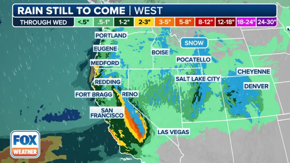
This graphic shows the forecast rain and snow totals across the West through Wednesday, Nov. 27, 2024. (FOX Weather)
Forecasters believe the highest rain totals will be found across Central California, with some places potentially picking up 5 inches of rain or more. Flash flooding doesn't appear to be a major issue at this time, but travelers will likely see some disruptions on the roads and at airports such as Salt Lake City (SLC), Las Vegas (LAS), Los Angeles (LAX) and San Francisco (SFO).
The system should then exit into the Rockies, where some questions remain about how it will evolve. The storm could strengthen into a new low, increasing the chances of rain and snow for a large swath of the Rockies.
Cities like Salt Lake City, Las Vegas and Denver are all likely to see some form of precipitation by Wednesday. The snow that falls in the mountains will likely be measured in feet, while the lower-elevation snow totals and impact will be largely dependent on the exact track of the storm.
As of Sunday, the FOX Forecast Center doesn't expect major impacts in Denver.
Winter storm to impact Thanksgiving travel in Northeast
A storm system will also move out of the Plains starting Sunday and quickly move into the Great Lakes region as we start the new week.
The FOX Forecast Center said that, unlike previous systems, this one isn’t expected to be as strong.
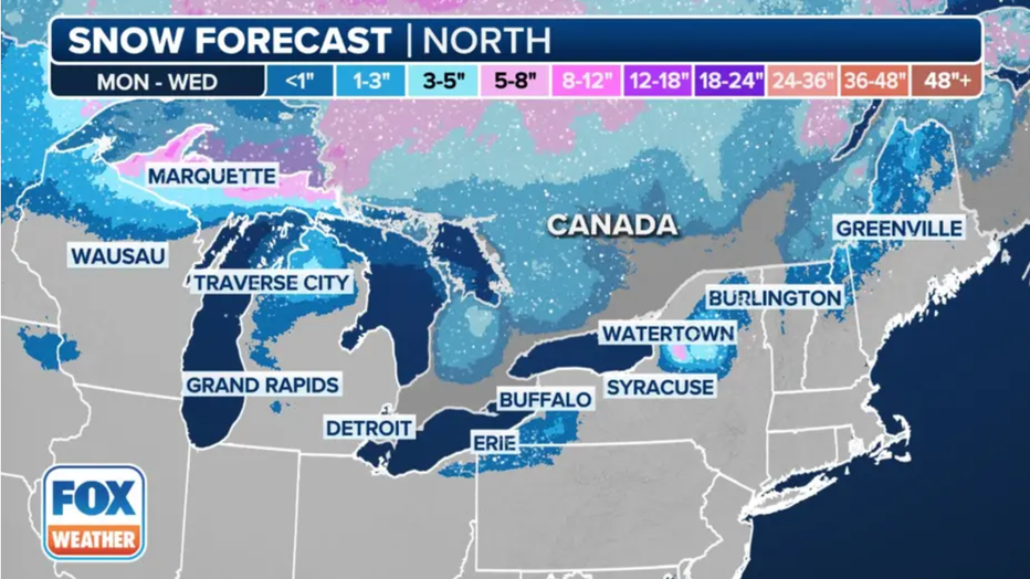
This graphic shows the forecast snow totals through Wednesday, Nov. 27, 2024. (FOX Weather)
The colder air will be kept farther north, which will limit the snow chances to the Great Lakes region. The Upper Peninsula of Michigan will likely see the highest snow totals as lake-effect snow cranks up.
Cities like Chicago and Milwaukee will largely avoid the snow, but the wind could begin to crank up as the system pushes out of the region, leading to some delays at airports and on the roads.
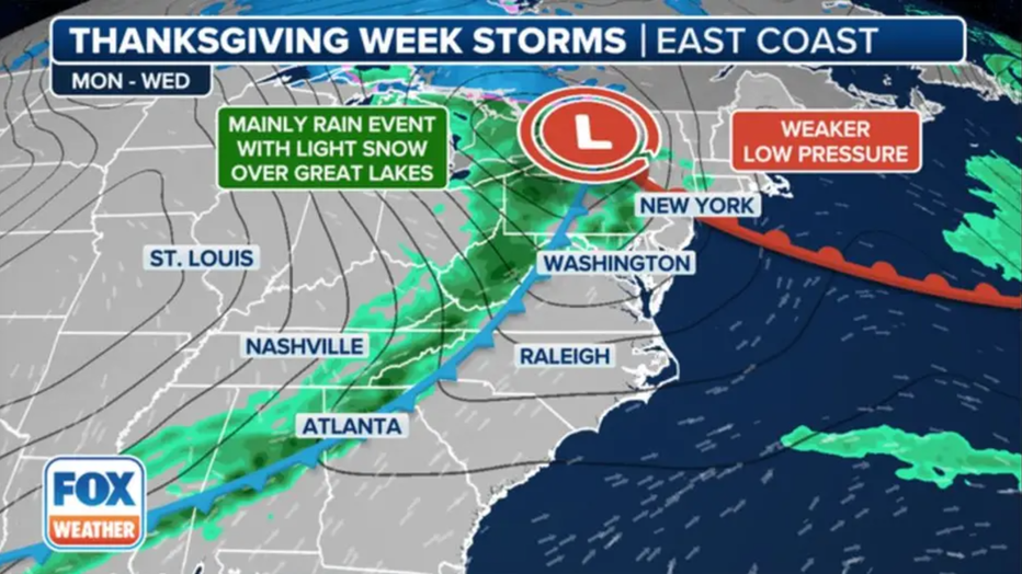
These graphics show the setup for a significant winter storm that could slow post-Thanksgiving travel for tens of millions of people in the East. (FOX Weather)
The low will continue to strengthen as it moves into the Northeast later this week, with rain breaking out on Tuesday that could slow travel times for those traveling before Thanksgiving.
Some snow is likely along Lake Erie and Lake Ontario, but rain will be the bigger impact.
Rain is expected to impact travel along the Interstate 95 corridor on the East Coast, and due to low visibility and increasing winds, all major airports are likely to see disruptions.
A cold front is also expected to sweep across the Southeast, which will bring a line of rain and thunderstorms to the region into Wednesday morning. No severe weather is expected, but periods of rain could lead to delays in Atlanta and Charlotte, North Carolina.
Frigid temperatures to invade U.S. after Thanksgiving
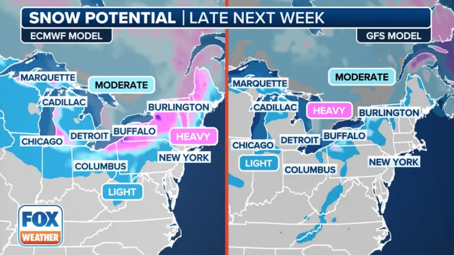
This graphic shows the computer model comparisons showing a winter storm in the Northeast that could slow post-Thanksgiving travel. (FOX Weather)
A bigger, more powerful winter storm is expected to then sweep into the Northeast and New England on Thanksgiving Day and last through the weekend. This storm will likely have a bigger impact on travel as people start their journeys home after Thanksgiving.
More rain is expected along the I-95 corridor, but there are growing concerns that heavy snow could blast interior areas of the region.
Blast The FOX Forecast Center expects some of the coldest air of the season to invade the U.S. from Canada in the days after Thanksgiving and into the start of December.
Below-average temperatures are expected across a large swath of the U.S., with parts of the northern Plains expected to plunge maybe as far as -10 degrees.

