Austin weather: Arctic invasion coming, will it bring snow?

Austin weather: Warm up and then snow ahead?
Temperatures have been mostly been below average in the new year. Zack Shields talks about temps warming up and then a big cold front in his full forecast.
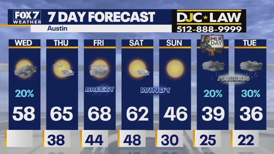
AUSTIN - The light rain is moving out, and eventually the clouds will break apart later today. It's still jacket weather with highs in the 50s and lows tonight in the 30s. Feeling more comfortable for the second half of the week with highs back in the 60s and then an Arctic front will blast through the area late on Saturday.
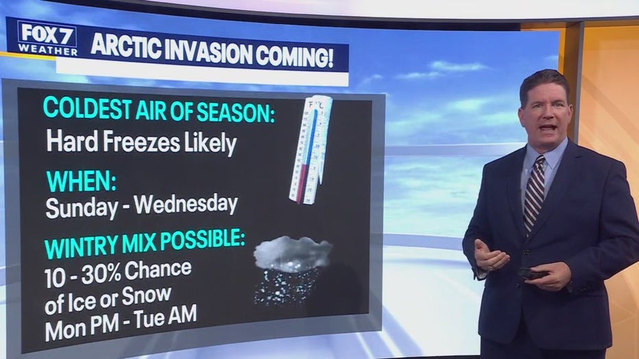
This front will usher in the coldest air of the season for several days and nights. So we are tracking a brief warm up, very strong front, gusty winds, hard freezes and even a slight chance of wintry mix.
What's the forecast for the rest of the week?
What we know:
Rain will move out today with the clouds eventually moving out. That will allow some sunshine through later in the afternoon with a high of 58. Tonight, with no blanket of clouds overhead, temperatures will drop into the 30s by the time you wake up.
There will be a lot of sunshine on Thursday, but then clouding up with a Gulf breeze turning feisty on Friday.
You will have warmer weather for three days with highs in the 60s.
When will the Arctic front arrive?
What we know:
Let's talk about the brutal cold that will hit Austin this coming weekend. It will also put most of Texas in a deep freeze.
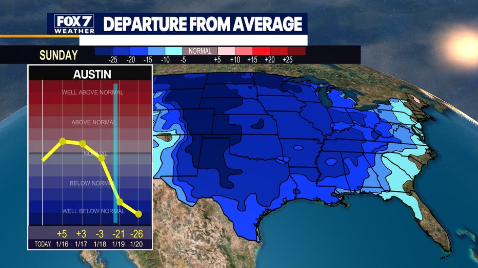
This system is expected to arrive in Central Texas late on Saturday. The high for the day will be in the low 60s, and it will be sunny and dry, but windy.
If you have outdoor chores to do, Saturday is the perfect day for you, unless you love the arctic chill that is moving in on Sunday.
The low for Saturday will be 48 degrees.
Will it snow in Austin?
What we know:
If you think it is cold outside now, just wait until Sunday and beyond.
The highs on Sunday will be in the 40s. It will be a full day of sunshine.
There will be a strong wind out of the north, making it feel like it is in the 20s and 30s outside all day. This cold air mass will stay with us into next week.
The low on Sunday will be only 30 degrees.
Monday Forecast: MLK Day/Inauguration Day
What we know:
The day will start out with lows in the mid 20s and will only get to a high of around 39 degrees.
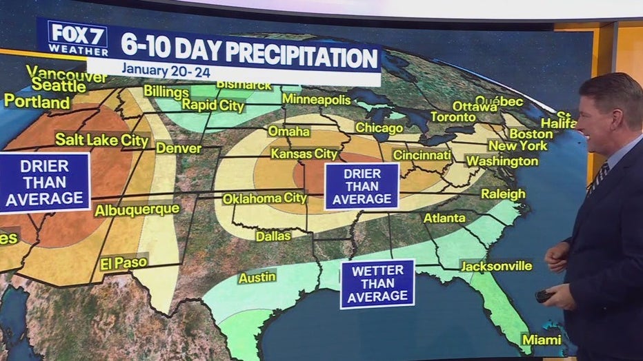
The Climate Prediction Center is saying it could be wetter than average across the South. It could be cold enough to support frozen precipitation that could sneak in late Monday into Tuesday next week.
There is a 20 percent chance of precipitation on Monday.
What we don't know:
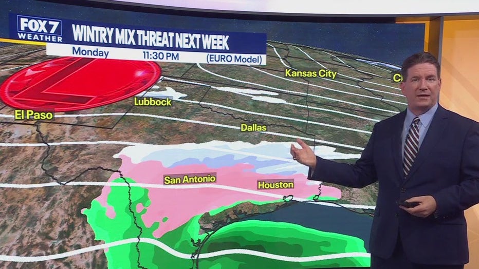
With the wintry mix predicted for seven days out, there is a lot that could change between now and then. We will keep an eye on the models and will update you as things progress.
Tuesday Forecast
What we know:
The arctic chill will be locked in on Tuesday with the day starting in the low 20s with a high predicted at 36 degrees. There may be enough lift and moisture with the western low for the possibility of sleet and snow from Austin to San Antonio and Houston.
A hard freeze will happen. This is likely the coldest air of the season from Sunday through Wednesday.
There is a chance of a wintry mix, mainly sleet, until Monday afternoon through Tuesday morning.
What we don't know:
The confidence is low that we're going to have enough moisture and lift to support a lot of snow and sleet. The best thing about the forecast is we have plenty of time to fine tune it. It is several days out.
The Source: Information in this article comes from the FOX 7 Austin Weather team.

