Austin Thanksgiving forecast: Rollercoaster weather, possible travel delays
Austin weather: Cold temperatures arrive
The chill is here! We'll get a quick bump back to warmer weather before we settle in to some winter-like weather. Zack Shields has all the details in his full forecast.
AUSTIN - Buckle up and get ready for a wild ride in the temperature department. Chilly today, warmer tomorrow and dropping again for Thanksgiving. When the second front arrives, the cold nights and chilly days will last through the weekend and into next week.

DOWNLOAD FOX LOCAL AND THE FOX 7 AUSTIN WEATHER APP
The next Western Low will march east through the Thanksgiving holiday. On Tuesday most of the rain and snow will stay from the Rockies to the West Coast. On Wednesday, the rain moves into the Midwest and then on Thanksgiving the rain moves toward the East Coast. In Texas, we will have dry skies and with up and down temperatures.
Thanksgiving Travel
Millions of Americans across the U.S. have started to pack the roads and airports ahead of Thanksgiving, but a powerful storm moving from coast to coast could snarl travel before the holiday and as people begin their journeys home after celebrating with family and friends.
The first half of the busy Thanksgiving travel week includes storms dumping rain and mountain snow in the West, while the eastern half of the country deals with rain, freezing rain and snow.
If that wasn’t enough to dampen the holiday spirit, the FOX Forecast Center is tracking another winter storm that could significantly impact travel in the Northeast as millions of people prepare to head home.
Let’s break it all down for you.
Winter weather wallops West
The FOX Forecast Center said that the last of a series of low-pressure systems is moving across the West Coast and into the Rockies, bringing winter weather and rain to the region.
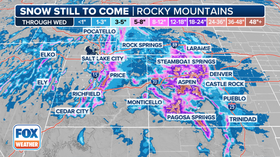
This graphic shows the forecast snow totals in the West.(FOX Weather)
This is the same system that brought heavy rain to California on Monday. As it continues on its journey to the east, it’s expected to develop into a significant winter storm across portions of Colorado and Utah.
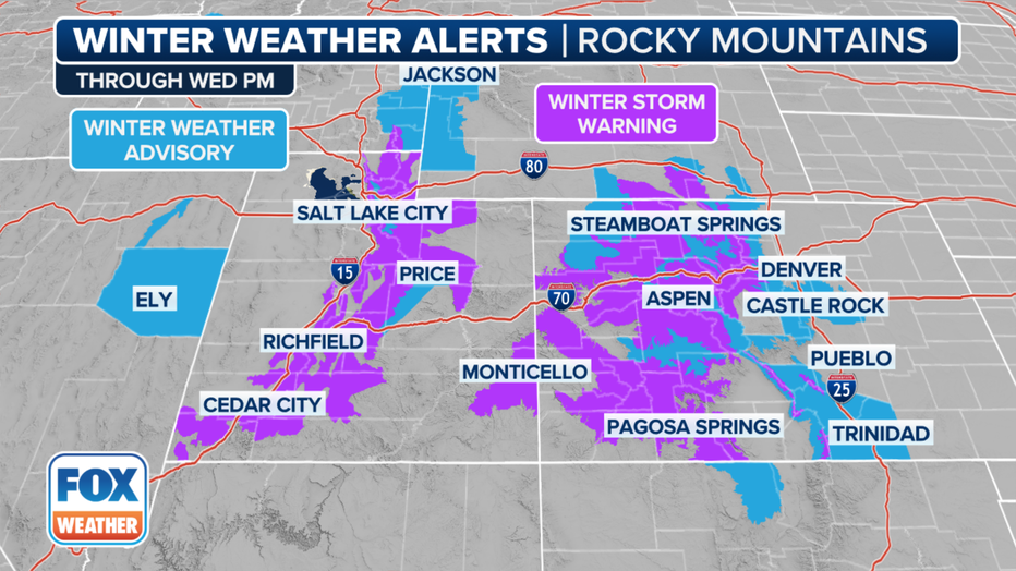
Winter Storm Warnings are in effect across the region in anticipation of snow totals that could reach up to 3 feet in the highest elevations.
That’s expected to make travel extremely difficult, if not impossible, across mountain passes as Thanksgiving approaches.
By Wednesday, Salt Lake City, Las Vegas and Denver could all see some form of precipitation.
However, the FOX Forecast Center doesn’t expect any major impacts in Denver at this time. Conditions could deteriorate on major highways like Interstate 25 and Interstate 70 before the system moves out of the region before Thanksgiving Day.
Rain, snow roll through the East
Millions of people across the eastern half of the U.S. are also getting in on the action and should pack patience as pre-Thanksgiving travel delays are expected Tuesday.
The FOX Forecast Center said a cold front extending from the Southeast to northern New England is producing rain, snow, freezing rain and even some rumbles of thunder in some spots.
Major airports in the East are likely to see some disruptions due to the large number of people traveling, inclement weather and low ceilings. Low visibility and gusty winds will be a concern as the system slides off the East Coast.
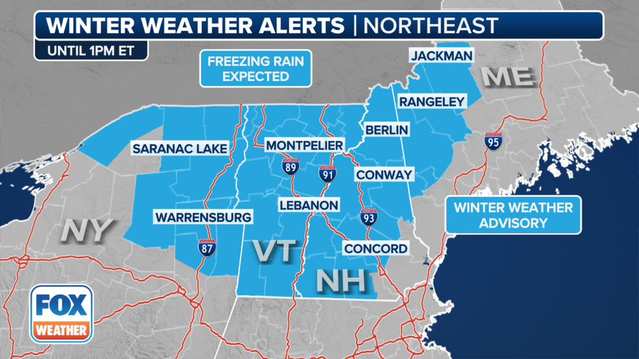
This graphic shows winter weather alerts in New England.(FOX Weather)
Farther north, where temperatures have been colder, freezing rain threatened to make travel hazardous in New England for those venturing out in parts of Vermont, New Hampshire and Maine.
The good news is that temperatures will rebound as the day continues and ice will begin to melt.
Severe weather is unlikely in the Southeast, but rain and possible thunderstorms could lead to delays at the world’s busiest airport – Hartsfield-Jackson Atlanta International Airport.
Most of the rain and thunderstorms will die down by Tuesday night.

This graphic shows the interstate driving forecast in the Northeast.(FOX Weather)
Thanksgiving Day Winter Storm
As if the pre-Thanksgiving travel troubles weren’t enough, the FOX Forecast Center is also tracking another winter storm on Thanksgiving Day that is expected to delay last-minute holiday travel, as well as for those shopping on Black Friday or starting their journeys back home.
This is all due to the winter storm that’s currently blasting the West. By Thursday, the system will be moving through the Midwest and Ohio Valley and into the Northeast.
The FOX Forecast Center expects a line of rain and thunderstorms to slide through the Southeast and Tennessee Valley on Thursday. Some of those storms could turn severe with damaging wind gusts.
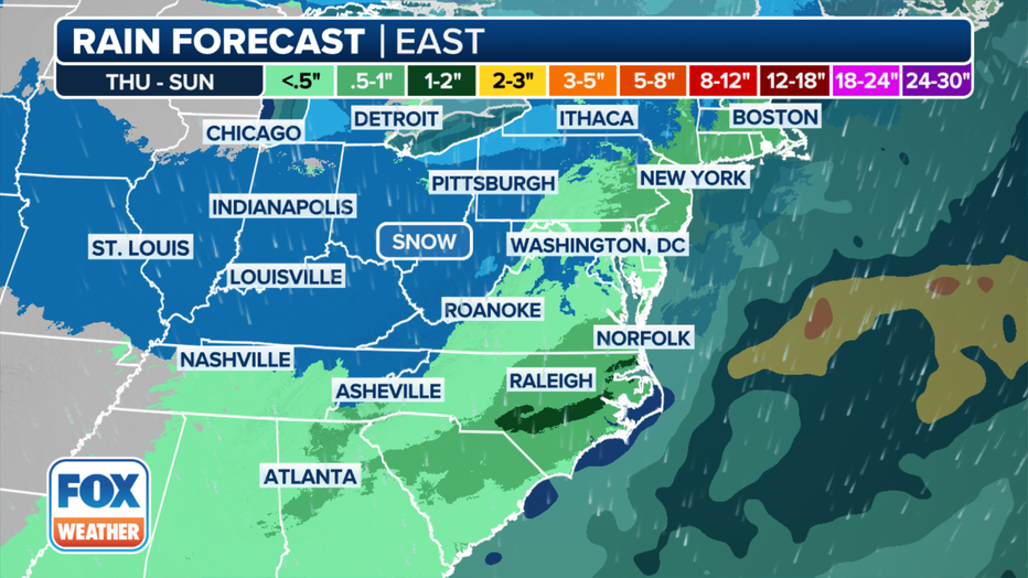
This graphic shows the rain forecast in the East.(FOX Weather)
For those of you who are driving on Thanksgiving, slowdowns on the roads and at airports are expected.
To the north, heavier rain is likely across portions of the mid-Atlantic and Northeast into Thursday night. The FOX Forecast Center said the system will strengthen as it approaches the region, and winds could also begin to kick up and cause delays at airports in Washington, Baltimore, New York City and Philadelphia.
Snow will break out from the Midwest to New England to the north of the low-pressure system. Cold air will initially be limited as the system exits the Midwest, but as the low strengthens, it will pull in colder air from Canada.
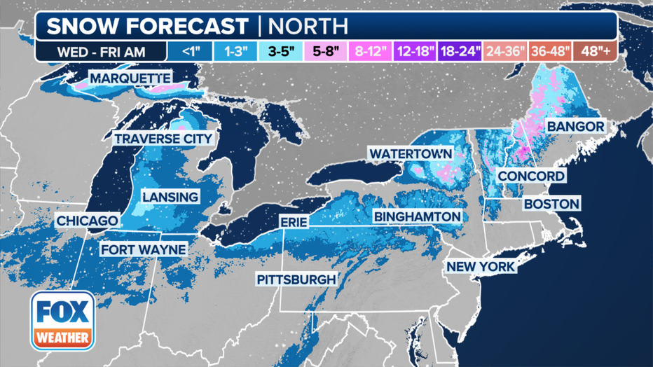
This graphic shows the forecast snow totals in the Northeast.(FOX Weather)
The FOX Forecast Center said snow totals are expected to be light except for portions of the interior Northeast. That’s where heavier snow could pile up across the region, particularly over the higher elevations.
Upstate New York, the Green Mountains in Vermont and the White Mountains in New Hampshire will all likely see snow as the low tracks offshore into Thursday night.
Cities in New York, such as Syracuse, Buffalo and Binghamton, will all likely get in on some accumulating snow, too.

